Precision Seismic
Survey Solutions
Built for Western Canada's most demanding environments.
Summit Geo Inc. delivers reliable, high-quality field services across the oil and gas and energy sectors, from early planning through execution, with crews built for the demanding environments of Western Canada.


%20--%3e%3csvg%20version='1.1'%20id='Layer_1'%20xmlns='http://www.w3.org/2000/svg'%20xmlns:xlink='http://www.w3.org/1999/xlink'%20x='0px'%20y='0px'%20viewBox='0%200%20173%2045.9'%20style='enable-background:new%200%200%20173%2045.9;'%20xml:space='preserve'%3e%3cstyle%20type='text/css'%3e%20.st0{fill:%23333333;}%20.st1{clip-path:url(%23SVGID_3_);fill:%23333333;}%20%3c/style%3e%3cg%3e%3cg%3e%3cpath%20id='SVGID_1_'%20class='st0'%20d='M17.9,42.4c6.8-1,11.5-6.5,12.2-12.5c0.5,0.9,0.9,2.6,0.9,4.1c0,5.3-4.3,8.8-9.6,8.8%20C19.7,42.8,18.3,42.5,17.9,42.4%20M33.9,14.4c-0.4-0.3-1.6-1.1-2.5-1.7c-3.3-2.2-5.8-3.5-5.8-5.9c0-1.5,1.2-2.6,2.8-2.6%20c2.9,0,6.3,2.6,6.3,2.6C39.9,10.6,43,16.6,43,23c0,2.5-0.4,4.4-0.7,5.3C42.3,25.4,40.6,18.8,33.9,14.4%20M6.7,34.7%20C4.3,31.3,3,27.3,3,23C3,12,11.4,4.2,20.7,3.1c-0.2,0.1-2.5,1.6-2.5,5.2c0,3.3,2.3,6.2,4.2,8.9c0.5,0.7,0.9,1.4,1.5,2.2%20c1.5,2.3,3.3,5.3,3.3,8.8c0,6.3-5.1,11.2-11.2,11.2C10.6,39.5,8,36.5,6.7,34.7%20M0,23c0,12.7,10.3,23,23,23s23-10.3,23-23%20S35.7,0,23,0S0,10.3,0,23'/%3e%3c/g%3e%3c/g%3e%3ctitle%3eStantec_logo_Black%3c/title%3e%3cg%3e%3cg%3e%3cg%3e%3cdefs%3e%3crect%20id='SVGID_2_'%20width='173'%20height='45.9'/%3e%3c/defs%3e%3cclipPath%20id='SVGID_3_'%3e%3cuse%20xlink:href='%23SVGID_2_'%20style='overflow:visible;'/%3e%3c/clipPath%3e%3cpath%20class='st1'%20d='M123.7,32.9c0,1.2-0.7,2.2-2.2,2.2s-2.2-1-2.2-2.2v-7.4c0-2-1-3.7-3.3-3.7c-1.7,0-2.9,1-3.8,1.7v9.4%20c0,1.2-0.7,2.2-2.2,2.2s-2.2-1-2.2-2.2V18.7h3.8l0.3,1.9c0.7-0.6,2.7-2.4,5.8-2.4c2.8,0,6.1,1.6,6.1,5.8v8.9H123.7z%20M81.7,30.5%20c0,0.9,0.7,1.5,1.5,1.5c1.4,0,1.8-1.1,2.8-1.1c0.9,0,1.4,0.7,1.4,1.4c0,1.5-1.8,2.8-5,2.8c-3.6,0-5.2-2.1-5.2-4.8v-8.5h-2.9v-3.2%20h2.9V15l4.5-1.2v4.9h5.9l-1.1,3.2h-4.8C81.7,21.9,81.7,30.5,81.7,30.5z%20M132.8,30.5c0,0.9,0.7,1.5,1.5,1.5c1.4,0,1.8-1.1,2.9-1.1%20c0.9,0,1.4,0.7,1.4,1.4c0,1.5-1.8,2.8-5,2.8c-3.6,0-5.2-2.1-5.2-4.8v-8.5h-2.9v-3.2h2.9V15l4.5-1.2v4.9h5.9l-1.1,3.2h-4.8%20L132.8,30.5L132.8,30.5z%20M56.8,31.2c0-1,0.8-1.7,1.7-1.7c1.5,0,2.6,2.1,6.4,2.1c2.3,0,4-1,4-2.7c0-1.5-1.2-2.4-3.1-3.3%20c-0.6-0.3-1.7-0.8-2.4-1.1c-2.6-1.2-5.2-2.9-5.2-6.3c0-3.3,2.9-6.1,8-6.1c3.7,0,5.9,1,6.4,1.3l-1.1,3.3c-0.6-0.3-2.8-1.1-5.1-1.1%20c-1.7,0-3.4,0.8-3.4,2.5c0,1.6,1.4,2.3,3.2,3.2c0.6,0.3,1.1,0.5,1.7,0.8c2.8,1.3,5.8,2.8,5.8,6.5c0,4-3.8,6.5-8.8,6.5%20C60.3,35.1,56.8,33.2,56.8,31.2%20M166.9,35.1c-5.8,0-9.2-3.8-9.2-8.4c0-4.8,3.5-8.4,9.2-8.4c3.3,0,5.1,1.2,5.4,1.4l-1,2.9%20c-0.3-0.2-1.8-1.2-4-1.2c-3.3,0-5,2.4-5,5.3s1.8,5.3,4.8,5.3c2.3,0,3.2-1.5,4.4-1.5c0.9,0,1.5,0.7,1.5,1.5%20C173,33.6,170.2,35.1,166.9,35.1%20M152.4,30.6c-1.2,0-2.1,1.5-4.3,1.5c-2.3,0-4-1.8-4.2-3.8h11.4v-1c0-5.3-2.9-9-7.9-9%20c-5.1,0-8,3.6-8,8.4c0,4.3,2.6,8.4,8.6,8.4c3.4,0,6-1.5,6-3C154,31.3,153.5,30.6,152.4,30.6%20M147.3,21.4c2.7,0,3.4,2.2,3.4,4%20h-6.9C143.8,23.4,144.8,21.4,147.3,21.4%20M103.7,30.1v-5.3c0-3.9-2.4-6.5-7.6-6.5c-3.6,0-6.1,1.3-6.6,1.6l1.3,2.7%20c0.3-0.1,2.4-1.1,4.4-1.1c2.8,0,4.1,1.5,4.1,3v0.2l-2.8,0.1c-4.1,0.2-7.6,1.5-7.6,5.3c0,3.1,2.5,5.1,5.9,5.1c2.9,0,4.4-1.5,4.9-2%20c0.1,0.3,0.6,2,2.7,2c1,0,1.6-0.4,1.6-1.3C104,32.8,103.7,32.2,103.7,30.1%20M99.2,30.8C98.9,31,97.7,32,96,32%20c-1.6,0-2.6-1-2.6-2.3c0-1.5,1.2-2.2,3.7-2.3l2.1-0.1V30.8z'/%3e%3c/g%3e%3c/g%3e%3c/g%3e%3c/svg%3e)

A full range of
field services.
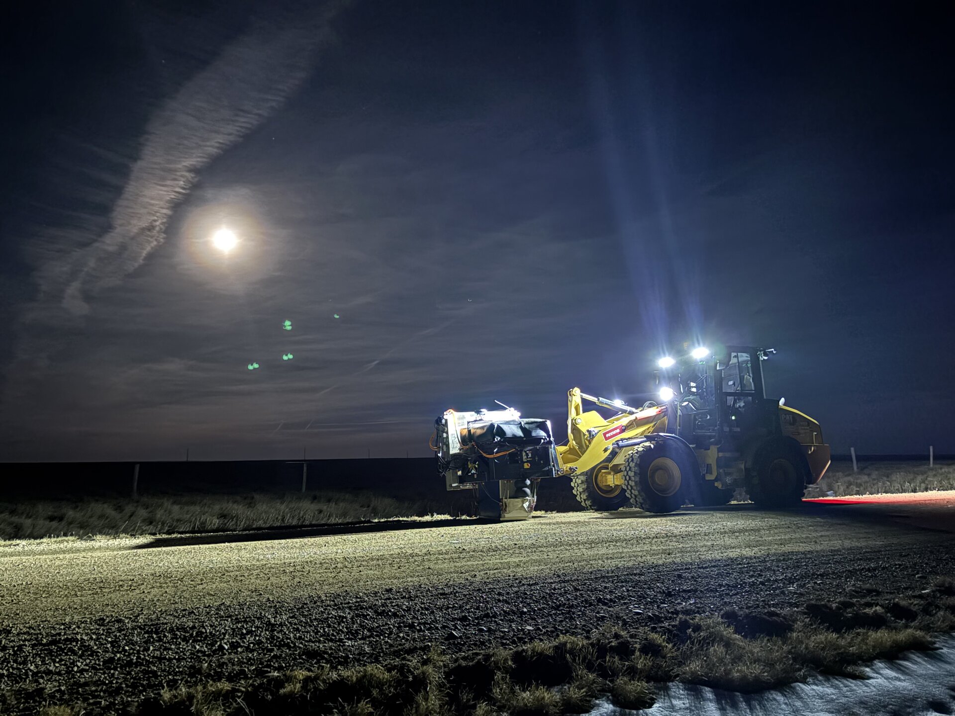
Geophysical Field Services
Field crews running dynamite-source and low-impact seismic programs with rigorous QC.
Seismic Line Clearing
Low-impact mulching and slashing to prepare seismic lines and access corridors.
Seismic Survey
High-precision GNSS positioning for staking and locating.
Lease Construction
Access development, pad preparation, and earthworks for wellsites and facility builds.
Vegetation Management
Integrated vegetation control for corridors, lease sites, and access routes.
GIS & Drone Services
Live GIS mapping of every field operation, with site surveillance and drone capture for full project visibility.
Creating prosperity within the community.
Summit Geo Inc. is an Alberta-based, Indigenous majority-owned company supporting projects across the oil and gas and energy sectors through our Vegetation Management and Seismic divisions.
With strong roots in Fort McKay, our team combines local knowledge, experienced crews, and modern equipment to execute projects safely and efficiently. Through our partnership with Integrity Industries North, backed by over 35 years of land clearing and vegetation management experience, we bring proven expertise and scalable capability to every project.
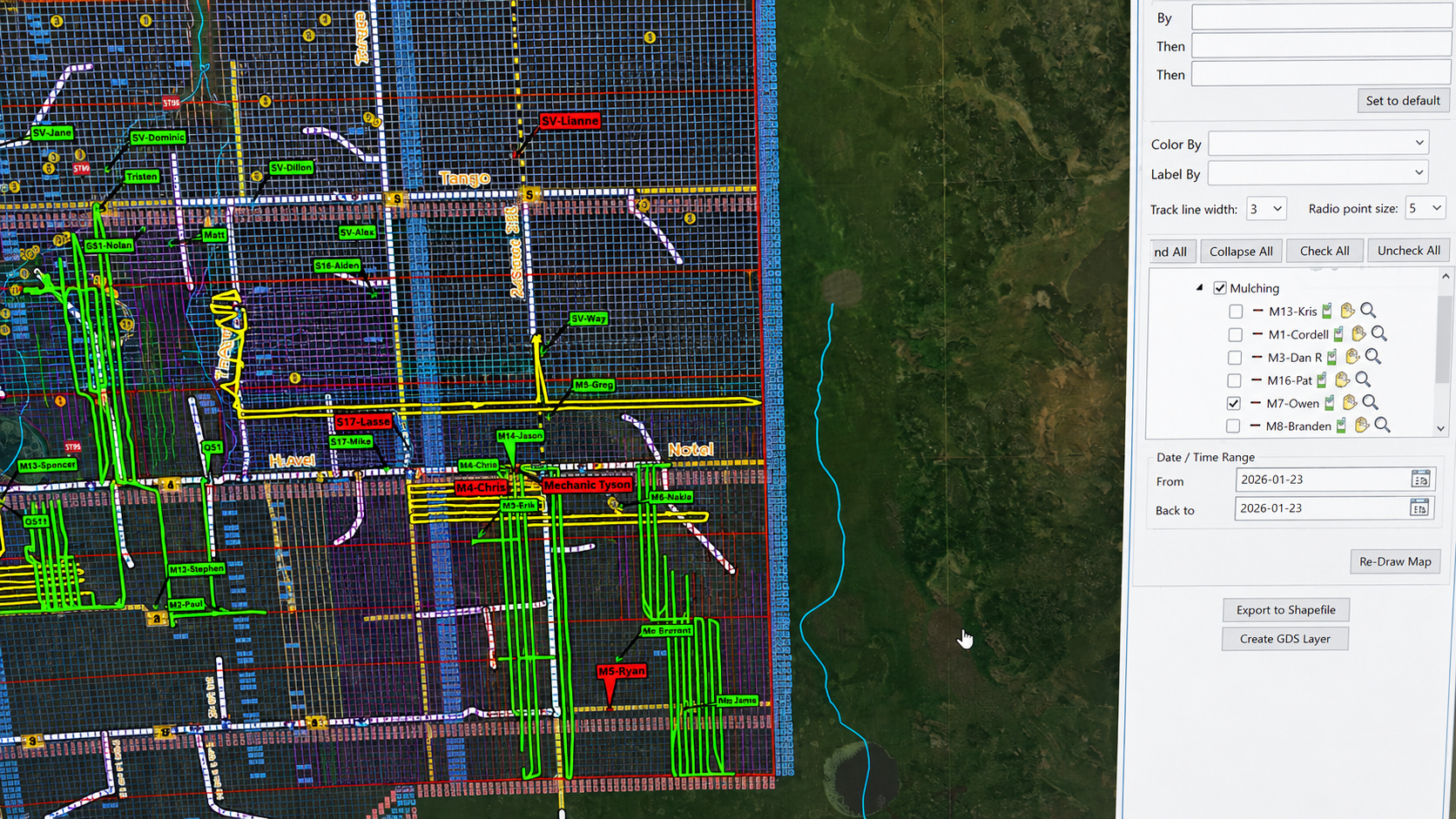
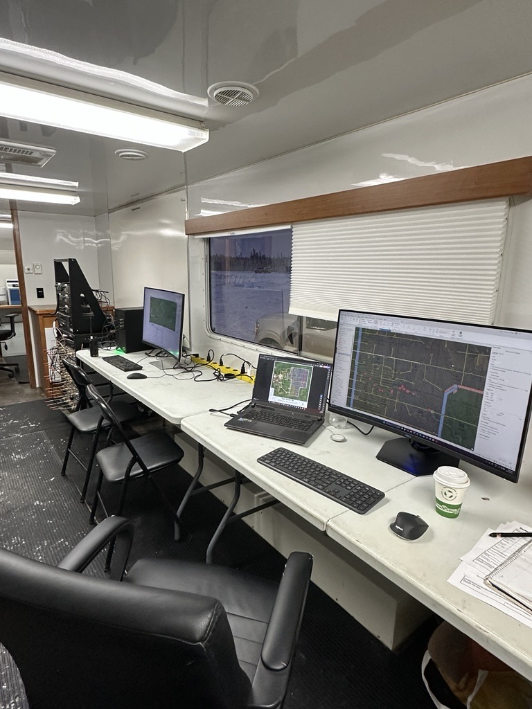
Collect. Display.
Analyze. Respond.
Our Site Surveillance technology delivers a turnkey solution for the energy sector, emergency services, and large-scale field operations, solving location services for multiple contractors on a single site, accurate accrued-cost tracking, and custom mapping and project communications in real time.
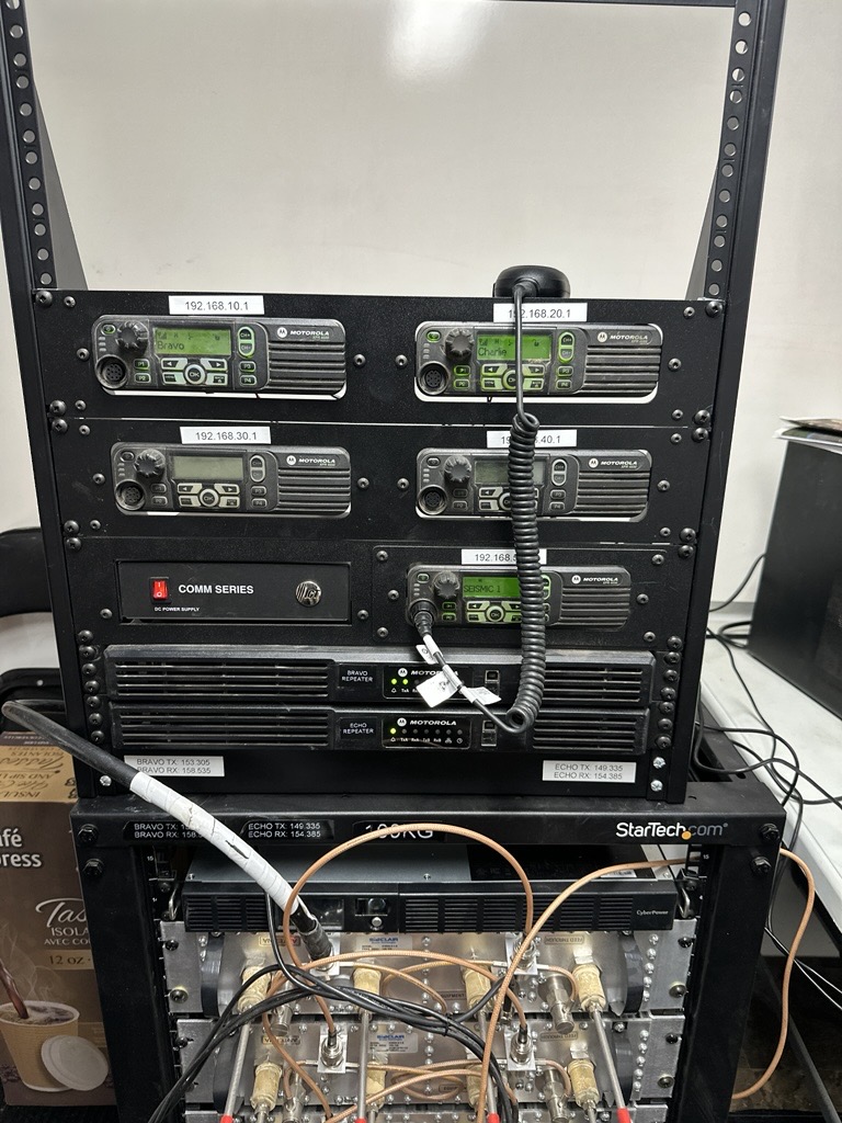
A robust radio network for multi-contractor sites, with or without cellular coverage, backed by standardized hardware and on-site technicians. Remote login lets managers review projects in real time.
High-quality situational maps with real-time tracking of people and equipment, covering tens of kilometres in any direction from a single work site.
Spatial data collected, analyzed, and supplied through clear reporting, ensuring equipment and personnel work efficiently and billable hours equal hours worked.
UAVs, photogrammetry, 3D modelling, and custom maps tailored to your work site.
Contact us for a demo on your work site.
Reliable. Responsible.
Built for the north.
Crews built for the conditions.
Experienced crews delivering seismic and field support across Saskatchewan, Alberta, and British Columbia, built for remote terrain and tight schedules.
Partnership over transactions.
Indigenous majority-owned, rooted in Fort McKay. We build long-term partnerships through accountability, safety, and dependable execution.
Risk down. Quality up.
GNSS positioning and technology-driven workflows that lower risk, lift efficiency, and keep quality high from plan to execution.
A core operational standard, not a checkbox.
We are COR certified and maintain active compliance through ISNetworld and Complyworks. Our programs are structured to meet and exceed regulatory and client requirements, with a focus on accountability, performance, and continuous improvement.


Plan your next field program with Summit Geo.
Tell us about your scope, location, and timeline. Our team will respond within two business days with a tailored proposal.